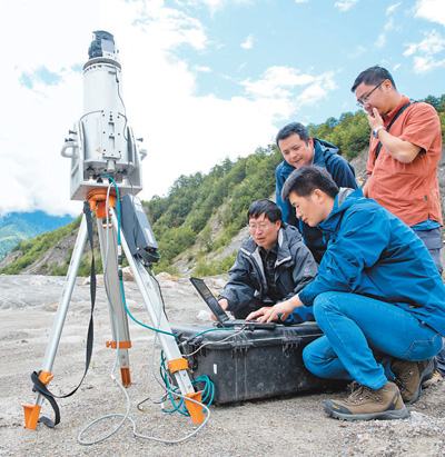
Experts from Chengdu Institute of Mountain Studies, Chinese Academy of Sciences are on the spot. Xinhua News Agency reporter Jin Liwang photo
Since ancient times, it has been difficult and dangerous to cross mountains and rapids from Sichuan to Tibet. Despite this, the pace of people laying "heavenly roads" has never stopped.
In 1950, the Sichuan-Tibet Highway started construction. Later, after 19 years of hard construction by 110,000 soldiers and civilians, it was fully completed and opened to traffic in 1969, thus ending the history of entering Tibet from Sichuan only by people and animals.
Now, in order to make this dangerous road more open, the construction of sichuan-tibet railway has also been put on the agenda and included in the national "Thirteenth Five-Year Plan". At the end of 2014, the Cheng Kang section and Lalin section of sichuan-tibet railway have started construction. At present, the construction of the whole line is being planned.
How difficult is the most difficult "heavenly road"
"Eight from eight volts", the cumulative climbing height exceeds 14,000 meters.
Sichuan-tibet railway starts from Chengdu, Sichuan in the east and reaches Lhasa, Tibet in the west, with a total length of nearly 1,700 kilometers. It includes three sections: Cheng Kang Railway (from Chengdu to Kangding, which is divided into Chengya Railway and Yakang Railway) and Kanglin Railway (Kangding — Linzhi), Lalin Railway (Lhasa — Linzhi). Sichuan-tibet railway is designed to run at a speed of 200km/h (the speed limit is 160km/h). After completion, it takes only 13 hours to get from Lhasa to Chengdu.
Compared with highways, the construction of railways is more difficult. How to avoid and prevent mountain disasters in railway line selection scientifically and reasonably has become a difficult problem to be overcome at present.
In 2015, China Academy of Sciences deployed the science and technology service network project "Distribution Law, Risk Analysis and Prevention Experiment Demonstration of Mountain Disasters in sichuan-tibet railway", and the researchers of Chengdu Institute of Mountain Disasters and Environment of Chinese Academy of Sciences (hereinafter referred to as Chengdu Institute of Mountain Disasters of Chinese Academy of Sciences) were entrusted with an important task. "We hope to further develop the discipline innovation chain of mountain disasters from theory to technology to application demonstration, and explore the ‘ Science — Technology — Engineering — User ’ Technology service model. " Wen Anbang, director of Chengdu Mountain Institute of Chinese Academy of Sciences, said.
In fact, the country began to explore sichuan-tibet railway as early as the early days of the founding of New China, and began to select routes in the 1990s. When we chose to build the railway into Tibet, we chose the Qinghai-Tibet, Sichuan-Tibet and Gansu-Tibet routes, but sichuan-tibet railway was temporarily put on hold because it was too difficult to build and the investment cost was too high.
You Yong is the chief engineer of Chengdu Institute of Mountain Studies, Chinese Academy of Sciences. He admits that this is the most difficult and intractable task he has encountered in his career for decades.
The construction difficulty of sichuan-tibet railway is rare in the world, and far exceeds that of the already-built Qinghai-Tibet Railway. More than 1,700 kilometers of lines have to go through "eight rises and eight volts", and the cumulative climbing height exceeds 14,000 meters. In the process of construction, builders will face four challenging problems: obvious terrain elevation difference, intense plate activity, frequent mountain disasters and fragile ecological environment. In other words, it is equivalent to building the world’s most technically difficult "giant roller coaster" between the most dangerous and complicated mountain canyons.
For example, the section from Luding County to kangding city, which is only 50 kilometers, has to climb nearly 2000 meters. "In order to overcome this huge terrain elevation difference and avoid disaster-prone areas, about 80% of the road sections along the line should be built on bridges and tunnels." You Yong further explained that along the sichuan-tibet railway, it also passes through the active earthquake fault zone of the Indian Ocean plate and the Eurasian plate, and faces various complicated geological conditions such as earthquakes, frozen soil, avalanches, geothermal, caves, underground rivers and rockbursts.
Why are there many mountain disasters?
It spans 14 major rivers and 21 snow-capped mountains over 4,000 meters.
After making a preliminary estimate of some difficult problems to be faced in the construction of sichuan-tibet railway, the researchers judged that "frequent mountain disasters" were one of the key factors to determine the success of the construction of sichuan-tibet railway.
This assertion has also been widely endorsed by the industry. In October 2016, an event called "Solving the Mountain Disaster Problem in sichuan-tibet railway — — ‘ Challenges and Countermeasures of sichuan-tibet railway Construction ’ " The academic exchange meeting was held. When talking about this issue, the eight academicians at the meeting also reached a consensus, that is, "building a railway under such a complicated geological environment will inevitably face a lot of scientific and technical problems, among which mountain disasters will become the key control node of the whole line."
"This is also the reason why the whole section from Ya ‘an to Linzhi in sichuan-tibet railway has not been started, because the mountain disaster problem faced by this section is the most serious and the construction is the most difficult, and it is still in the pre-feasibility study stage." Chen Xiaoqing, deputy director of Chengdu Mountain Institute of Chinese Academy of Sciences, said.
What the team of experts from Chengdu Mountain Institute of Chinese Academy of Sciences has to do is to try to solve the "mountain disaster" problem in this section.
According to the preliminary route plan, sichuan-tibet railway will cross the Hengduan Mountains, the plateau and alpine valleys in southeastern Tibet, and cross 14 rivers and 21 snow-capped mountains with a height of more than 4,000 meters.
"According to our statistics, the mountain disasters that may be encountered along the line include landslides, mudslides, water damage, snow damage, ice damage, and sand sliding slopes." You Yong said, "There are only 399 disaster spots where glacial lake burst and ice-water debris flow may occur on the 271-kilometer-long section of Palong Zangbo, sichuan-tibet railway. In the 360-kilometer-long fresh water section, there are 310 mudslides and 241 landslides. "
Why are mountain disasters so frequent and serious here?
Kelvin Cui, an academician of China Academy of Sciences and deputy director of Chengdu Mountain Institute of Chinese Academy of Sciences, said: "There are three main reasons: First, it spans multiple seismic zones, with active structure, frequent strong earthquakes and strong erosion, and has extremely favorable geological environment conditions for disasters; Second, the terrain with high drop and steep slope in the middle and high mountains provides huge energy conditions for disaster development; Third, due to the influence of monsoon and westerly belt, the climate difference is obvious, which provides favorable climate and water source conditions for disaster development. "
How to treat the key ills?
The technical consultation report on mountain disasters across the board is expected to be completed by the end of this year.
"Before giving the countermeasures, we must find out what is the regional distribution law of mountain disasters such as mudslides and landslides along the sichuan-tibet railway? How much influence do they have on railway engineering? How to scientifically divide the dangerous areas and safe areas of railway mountain disasters? " You Yong said, "In addition, sichuan-tibet railway will cross some places that our researchers have never observed before. Is there a mudslide there? How harmful is it? We don’t have any information in our hands, and we still need to investigate and study. "
The researchers of Chengdu Institute of Mountainous Areas of Chinese Academy of Sciences first used remote sensing satellites to find out the number and distribution status of collapses, landslides and debris flows along the railway, and then conducted more detailed research and analysis by consulting historical data, field reconnaissance, field sampling, experimental analysis and numerical simulation.
"Remote sensing images can’t see the internal structure of the slope, so it needs to be combined with field investigation." Li Xiuzhen, an associate researcher at Chengdu Institute of Mountain Studies, Chinese Academy of Sciences, said, "For example, we researchers must use some climbing ‘ Soil method ’ Climb to the top to find some traces that can be distinguished by the naked eye when the previous disasters occurred. According to these traces, we can calculate the scale, flow, impact speed and hazard mode of the disasters at that time. "
Find out the situation of mountain disasters, what kind of prevention and control countermeasures should be taken?
Chen Xiaoqing said: "In our researchers’ opinion, if the risk is particularly high, we will take ‘ Avoid ’ The way. If the problem can be solved and the cost can be saved, find a way to ‘ Governance ’ 。”
For example, Ridigou is a debris flow ditch near kangding city, Ganzi Tibetan Autonomous Prefecture, Sichuan Province. "The risk assessment of mountain disasters such as debris flow, collapse and landslide in this ditch and its prevention countermeasures are one of the most important prerequisites for determining the route selection of this section of the railway." Liu Jinfeng, an associate researcher at Chengdu Institute of Mountain Research, Chinese Academy of Sciences, said.
According to the previous route plan, a pier was originally set near the center of the Ridigou Railway Bridge. However, after investigation and research, researchers found that the Ridigou railway bridge may be affected by two kinds of collapse and rolling stone disasters. One is that the slope and dangerous rock disturbed by the project near the tunnel entrance may loosen and fall, and the falling rolling stone at a high place may move along the slope, which may cause harm to the railway line.
"Therefore, we feel that this position takes ‘ Railway arch bridge scheme+gap dam retaining at the upstream of railway bridge+protection and drainage under railway bridge ’ The combination method is more suitable. " You Yong said, "Just like this, we have to find out the countermeasures for mountain disasters along the route. The technical consultation report on mountain disasters across sichuan-tibet railway is expected to be completed by the end of this year." (Reporter Wu Yuehui)
关于作者